| |
|
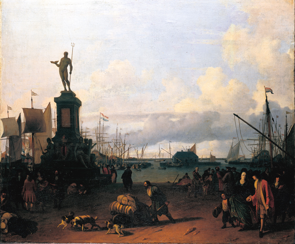
Sky over the HarbourOn the meteorology in Ludolf Backhuysen's "Am Hafen von Amsterdam " [At the Harbour of Amsterdam"], 1700, 86 x 103 cm, oil/canvas/wood, Städel Museum, Städel Museum, Frankfurt/M., Germany Franz Ossing,
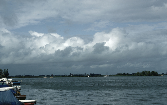
GFZ German Research Centre for Geosciences, Potsdam, Germany This view of the harbour at Amsterdam is likely imagined. It shows a section of the port basin looking toward the north. The northern bank of the Ij is at the horizon. The flags on the ships' masts reveal that the wind is blowing from the left, or from the west. Inflated sails (at left, near the frame) and the fluttering of the flags indicate a moderately strong wind. There are clouds in the sky at three levels. The right third of the painting is dominated by strong heap clouds (cumulus), Cumuli are likewise found near the centre of the painting. At the horizon, high towers of clouds are moving across the scene. A dark band of clouds which stretches horizontally across two-thirds of the painting, dominate the sky's impression. Exactly at the point where the main and the secondary diagonals intersect, a vertical swelling can be seen within this dark band of clouds. A horizontal, line-shaped cloud stripe stretches directly over this swelling. A corresponding line can be found in the upper right section of the painting. But the better part of the sky here is pale blue. Like almost all Dutch landscape paintings of the 17th century, this painting of Backhuysen's features a sky that appears realistic, corresponding to a typical weather situation in our latitudes. The clouds in the painting It is difficult to determine exactly which types of clouds are in this painting: according to the nomenclature of the World Meteorological Organization (WMO 1987), the above-mentioned cumulus clouds can be classified as cumulus congestus, which reach into the middle level of the atmosphere here. The dark band of clouds can be identified as stratocumulus, with clear swelling on the top side due to instable atmospheric stratification. A second, similar cloud can be seen at the same height behind this cloud mass at the left side of the painting. Both of these clouds are classified among the low level cloud types. Mid-level clouds can be found in at least two places in the painting: the narrow, horizontal band is altocumulus as is the narrow smudge of clouds closer to the front of the perspective at upper right. A veil of high ice clouds (cirrostratus) gives the sky its pale blue colour. How does such a sky develop? Cumulus clouds result as vertical instability in the atmosphere comes back into balance. This instability transports air upwards (convection), which condenses as it rises, forming cumulus clouds. These often cause rain showers, as indicated in the painting. If these processes are strong enough, they often cause a secondary mixing by turbulence in the air layers close to the ground which in turn leads to the formation of flat clouds in such an unstable air. With sufficient moisture and energy, the condensation processes taking place in these flat accessory clouds generate a swelling on the clouds' top side (as seen in the painting at the intersection of the main and secondary diagonals). Actually, such an instable, stratified atmosphere should not allow the formation of horizontally stratified clouds. Nevertheless, we can see mid-level altocumulus clouds (colloquially described as "fleecy" clouds) spread out horizontally. The towering cumulus cloud in the painting reaches a level above this layer. In addition, an expansive layer of cirrus (cirrostratus) is located in the upper storeys of the high clouds. However, this meeting of convective clouds and stratus clouds in the atmosphere is not uncommon; in fact, this occurrence corresponds well with the weather conditions in the temperate latitudes. The Weather Situation in the Painting The weather in the temperate latitudes is characterised by the constant interplay of high and low pressure areas. High pressure areas generate sinking air movements, which stabilize the atmosphere and clear the sky of clouds. In contrast, low pressure areas cause air masses to rise, they bring clouds with them. In the classic model of a low pressure area, the warm, stably stratified air arrives first. As the warm front draws near, the clouds thicken: first, a few high, feathery cirrus clouds appear, which then cross over into high, icy veils (cirrostratus). The cirrostratus cloud thickens into mid-level altostratus, which in turn develops into low-lying nimbostratus clouds with incipient rain showers that will likely last awhile. All of these clouds are formed in horizontal layers (stratiform). When the warm front arrives, the rain stops, and the so-called warm sector is established. Then the cold front pushes in from the west, bringing cooler air with it. The accompanying instability generates the convection clouds as described earlier (heap clouds, rain showers or even a thunderstorm). Because cold fronts move faster than warm fronts, mature low pressure areas have a front structure that looks like a zipper with the fronts zipping together from the core of the low toward the outer rim. This "zipped" section is known as an occluded front. Such an occluded front has the characteristics of either a cold or a warm front, depending on the air masses which make up the low pressure area. However, occlusions always feature both convective and stratiform clouds. These are exactly the weather conditions represented in Backhuysen's painting. The occluded front has already moved through; in the painting we can see convective cumulus clouds with showers and, at the same time, stratiform clouds such as cirrostratus and the altocumulus layer as well as stratocumulus or stratus in the lowest layer of the atmosphere. The photo above (Fig.2) demonstrates such a situation. It was taken in Terhorne (Westfriesland, the Netherlands) on 20 August 1981 at 5:40 p.m. A horizontally stratified altocumulus layer can be seen at the upper edge of the picture. In the hole between the clouds we can see cirrostratus. The mid-section of the photo is dominated by towering cumulus clouds with a narrow band of low stratus clouds with a light swelling formation on its top side is floating in front. The photo was taken looking toward the northeast and a moderately strong wind was blowing from WNW. The weather conditions produced are as follows: a cold occluded front has already passed through, displacing the maritime polar air. The maritime arctic air moving in in its wake destabilizes the air mass, generating showers. These weather conditions are the result of temperature contrasts that are somewhat more pronounced than the situation represented in Backhuysen's painting, but are otherwise identical. The weather situation described here is typical for the temperate latitudes in Europe. However, the underlying process, which includes vertical transport of air and a horizontally stratified atmosphere can also be observed in the tropics. Fig. 3 shows cumulus clouds with pronounced swelling. These clouds are rising up through an altocumulus layer. This layer at the photo's mid-section is at the same height as the clouds at the upper edge of the photo. This layer corresponds to the horizontal altocumulus layer and the broken up altocumulus clouds in Backhuysen's painting.
Literature: Berliner Wetterkarte [Berlin weather map] 20.08.1981, ISSN 0177-3984, Berlin Krempel, León, 2005, "Holländische Gemälde im Städel 1550-1800", Bd. 2, Imhof-Verlag,/Städelsches Kunstinstinstitut, Petersberg/Frankfurt a.M., here: pp. 22-28 WMO (World Meteorological Organization), 1987: "International Cloud Atlas", Vol. 11, WMO, Geneva, Switzerland, 212 pp. Many thanks
to the Städel Museum
for their kind support and for the opportunity to reproduce Backhuysen's
painting here.
Source: http://bib.gfz-potsdam.de/pub/wegezurkunst/ A contribution
to the
"Jahr der Geisteswissenschaften 2007"[Humanities Year] Please activate JavaScript in your browser. |